
This post was written by Lisa Cutting, 2002-2020 Eastern Sierra Policy Director, 2000-2001 Environmental Resource Coordinator, and 1999 Mono Lake Intern.
Mono Lake Committee staff are constantly looking out for activity that conflicts with agency management plans or that threatens the Mono Basin. At the end of last year, one such thing caught our eye: a development inquiry for a remote, undeveloped, 49.3-acre inholding in Lundy Canyon.
The inquiry was listed on the public meeting agenda for Mono County’s Land Development Technical Advisory Committee (LDTAC), which provides early coordinated technical review of development projects and educates applicants on Mono County regulations and requirements.
Too good to be true
The LDTAC inquiry was made by a potential buyer who was lured into the purchase of the property under the assumption that it would be possible to build a cabin on the site. For someone who has never been to Lundy Canyon, the concept of a remote inholding probably sounded appealing—the property is surrounded by Inyo National Forest land and adjacent to the Hoover Wilderness.
But the reality is that the parcel was once a mine site, almost-exclusively consists of an extremely steep talus slope, and has no feasible building site. The potential buyer was dutifully checking in with the LDTAC in the course of doing due-diligence on the feasibility of building a seasonal floating houseboat-type cabin where the property touches a beaver pond.
Fairly quickly the potential buyer realized that those plans were not going to work. There is no road to the parcel, and there are issues of permitting authority with building dwellings on water. The initial list of permits needed was long—Inyo National Forest, Army Corps of Engineers, Lahontan Regional Water Quality Control Board, and California Department of Fish & Wildlife, to name a few.
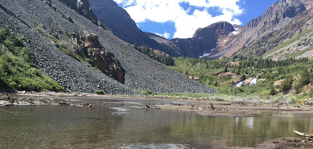
On top of all of this, the beaver pond is no longer there. Last year’s high streamflows broke through the beaver dam, turning the pond into a mudflat. For those familiar with Lundy Canyon, the property is on the south side of the first pond you come to approximately one quarter-mile from the trailhead (see photo above).
When issues lead to opportunities
Given the parcel’s proximity to adjacent public land and the challenges of actually building anything on the site, the most appropriate outcome would be to add it to the Inyo National Forest. The Committee has been working toward that goal, and we connected the potential buyer with several land trusts with which options are currently being discussed. The Committee also connected the potential buyer with helpful people in the local community, such as local Lundy Canyon historian Linda LaPierre. Linda’s meticulous records and knowledge of historic mining claims and parcels helped unravel some legal mysteries and expedited clearing the title on the property.
The good news on this issue is that everyone agrees that the best outcome for the property is to secure long-term conservation, ideally by transferring ownership to the Inyo National Forest. There are several paths to achieve that goal—all of which are currently being explored. Most important is that spectacular Lundy Canyon be protected as public land for all to enjoy. The Committee is doing everything possible to make sure that happens.
This post was also published as an article in the Winter & Spring 2018 Mono Lake Newsletter (page 6).