
The Mono Basin has had a very wet runoff year (more than 200% of average), but from a stream restoration perspective, what matters is how quickly the runoff melts, because the resulting flows dictate what kind of ecosystem processes occur.
Mild temperatures throughout the spring and the early summer months produced a somewhat diminished peak flow compared to what could have occurred. Even though 2023 had more snow than 2017, streamflow gauges and preliminary field data suggest that the 2023 peak flow events were similar to 2017 for most of the creeks in terms of flow magnitudes and channel activation, with one notable exception (see Mill Creek box below).
But let’s be clear, 2023 was an exceptional year for stream restoration. In the Rush Creek bottomlands, large and small ponded areas formed as water fanned across floodplains and reoccupied dry side channels. In Lee Vining Creek below town along the creek trail, the usually dry channel that hugs closest to the trail was flowing with enough force to mobilize cobbles and woody debris. These occurrences only happen in wet runoff years. And in extremely wet runoff years like 2017 and 2023, flood events have the power to alter the shape and structure of the creeks in ways that can allow water to flow to these hard-to-reach areas more readily in the future.

Exactly how the shape and structure (i.e., morphology) of the creeks change over time, especially after a wet year, is complex. In 2017, large flows opened channels on Rush Creek that have since stayed open and flowing with water even during low flow periods in winter and drought years. But not all channels can and will respond this way. To track the condition and trajectory of the stream restoration ordered by the California State Water Resources Control Board, Stream Monitoring Directors Bill Trush and Ross Taylor measure stream morphology conditions and fishery population health annually. The Mono Lake Committee assists with these efforts by collecting and sharing stream temperature data and groundwater depth measurements. Data and technical reports point to a couple of broad takeaways regarding the ongoing stream restoration.
First, multiple decades of restoration have not resolved the ecological damage that occurred in the streams resulting directly and indirectly from the Los Angeles Department of Water & Power’s (DWP) 50 years of excessive diversions, but conditions are improving dramatically in many areas. The simple fact that Rush and Lee Vining creeks have riparian habitats that can withstand 900 cubic feet per second (cfs) and 600 cfs peak flow events, respectively, and produce dramatic restoration benefits for the stream ecosystem is a testament to progress. Even 20 years ago there would have been concern about releasing flows at these magnitudes into the creeks, but through thoughtful restoration and monitoring approaches over the years, the creeks have robust vegetation and strong root systems that provide bank stabilization during more natural, sometimes extreme, flood events. A multitude of challenges still exist both for the fishery as well as each stream’s morphology, but overall, the ecological processes that promote a healthy stream ecosystem have been secured thanks to the 2013 Mono Basin Stream Restoration Agreement and are now being delivered as part of the 2021 amended water license for DWP.
Second, the stream ecosystem is recalibrating and likely will be for some time. Lee Vining and Rush creeks are clearly going through a midlife crisis of sorts; after having been relatively stable for thousands of years, stream diversions and low lake levels over the last century forced destructive changes onto all of Mono Lake’s major tributaries. While in 2017 and 2023 we can observe major alterations occurring in these creeks, such as the establishment of apparently new channels and wetlands, over time and after additional wet years, we expect that each stream system will eventually settle and experience much less change during extreme-wet years. Tracking these changes is, therefore, critical in the coming years as we seek to understand how these systems are adjusting and identify restoration successes as well as shortcomings.
So, there’s more work to be done. Policies are in place that require streamflow release patterns that seek to maximize stream health, but thankfully, those rules include critical “flexibility provisions.” Called out in the amended license, the Stream Monitoring Directors can utilize new data and information to adaptively adjust how DWP releases water into the streams on a year-to-year basis if it would promote better stream restoration outcomes, and therefore, their monitoring continues to be a critical element of the stream restoration effort. And as this runoff year ends and the creeks transition to their lower fall and wintertime flows, we will continue to learn what restoration opportunities exist and how they can be optimized, no matter how wet or dry next year will be.
Mill Creek’s dramatic runoff season
Mill Creek is Mono Lake’s third largest tributary stream and it experienced a much more dramatic runoff season below the Lundy Lake Reservoir dam in 2023 compared to 2017. Water releases from Lundy into Mill Creek were larger and lasted longer in 2023 with a peak flow that reached approximately 240 cubic feet per second (cfs) compared to 195 cfs in 2017. The larger flows opened historic side channels in Mill Creek and a rapid expansion of riparian and meadow habitat has been establishing as a result.
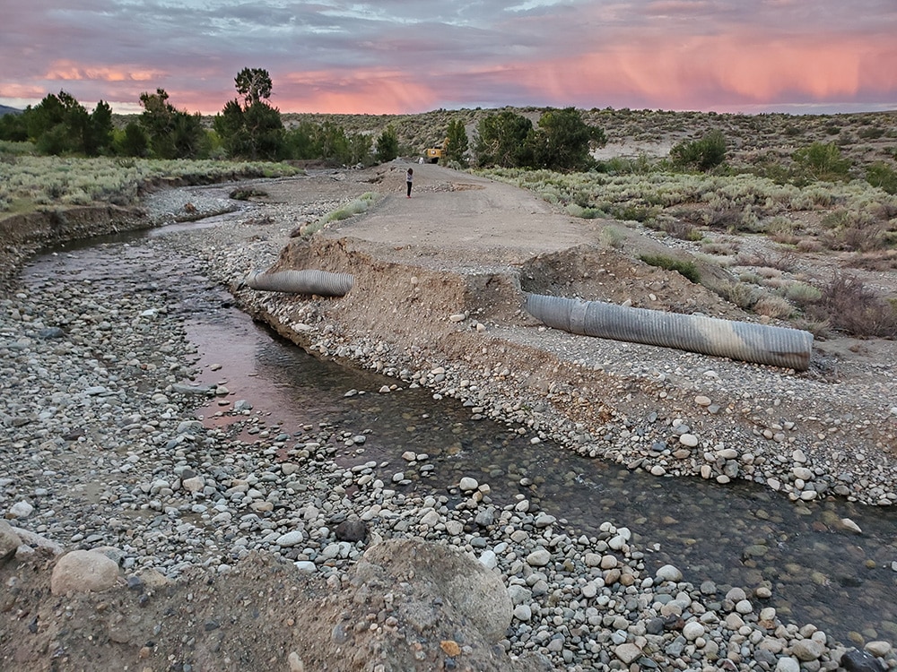
Unfortunately, culverts on Cemetery Road are not big enough for the larger flows that occur in wet years, let alone extremely wet years like 2017 and 2023. To make matters worse, these small culverts are Mill Creek’s only defense in preventing nearly 15 feet of streambed incision from traveling upstream through the Mill Creek bottomlands, which would occur if the culverts were to blow out due to high flows. This amount of streambed incision would threaten the survival of hundreds of trees that have been re-establishing along Mill Creek over the last three decades.
Thankfully, land managers worked hard to protect these culverts for most of the season, diverting water into usually dry historic channels, but there were times (inevitably on a weekend) when Mono Lake Committee staff had to mobilize on a moment’s notice to sandbag and fortify the culverts from large flows. The Committee is hoping to work with land managers to identify a long-term solution that will make management less cumbersome in future wet years, while also providing more long-lasting protections for Mill Creek.
This post was also published as an article in the Fall 2023 Mono Lake Newsletter. Top photo by Greg Reis: The Mono Lake Committee and Stream Monitoring Directors kept a close eye on Mono Basin streams as unusually high peak flows reshaped channels, wetlands, and streambanks.