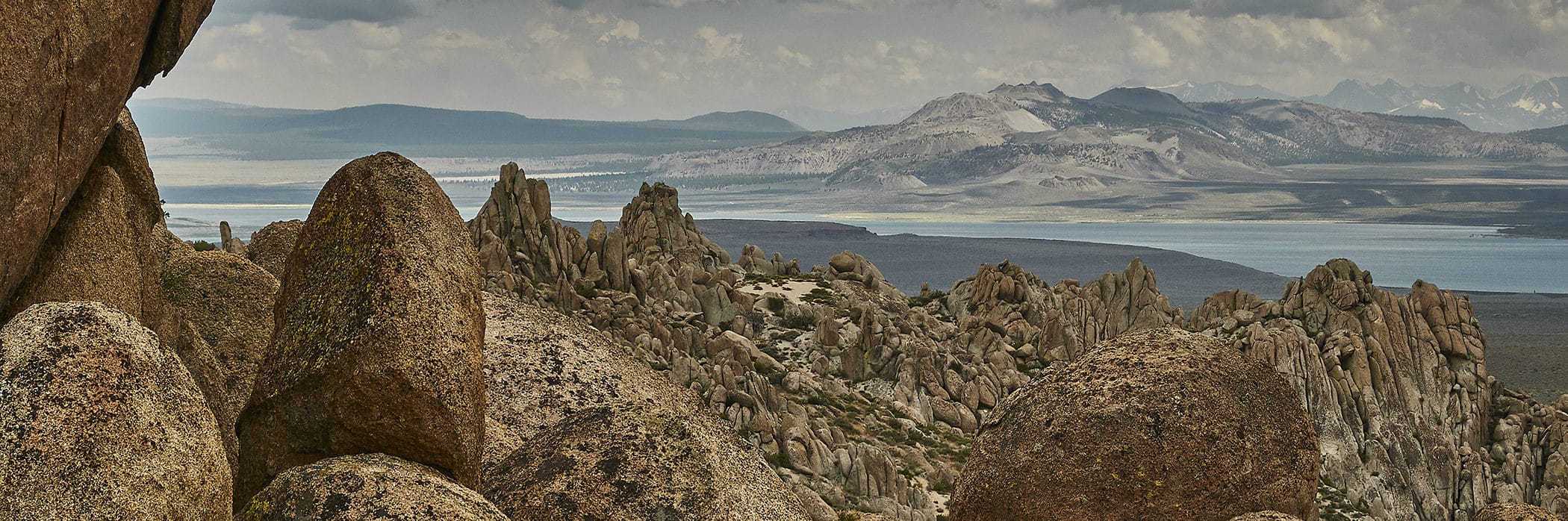
The Mono Basin is a land of extremes: very old features like the Sierra Nevada next to very young ones like Panum Crater, landscapes created by volcanoes next to those sculpted by glaciers, and immediate changes imposed on long, slow geologic processes.
The big picture: Tectonics of the Eastern Sierra
The Mono Basin lies at the complex transition area between two major geologic regions: the North American Western Cordillera (which includes the North American Plate boundary and Sierra Nevada) and the Basin and Range physiographic province.
Tectonic activity—the movement of plates of Earth’s crust—is key to understanding the big-picture setting of the Mono Basin. The collision of the North American Plate with oceanic crust—the Farallon Plate and later the Pacific Plate—is what caused the formation of the Sierra Nevada mountain range. The Farallon Plate, a thin plate made of cold, dense rock, collided with the North American Plate and was forced to subduct beneath North America. As the Farallon Plate sank into the mantle, it contributed to melting in the subduction zone, and the buoyant blobs of melt rose back up through the crust, forming the granite rock called the Sierra Nevada batholith.
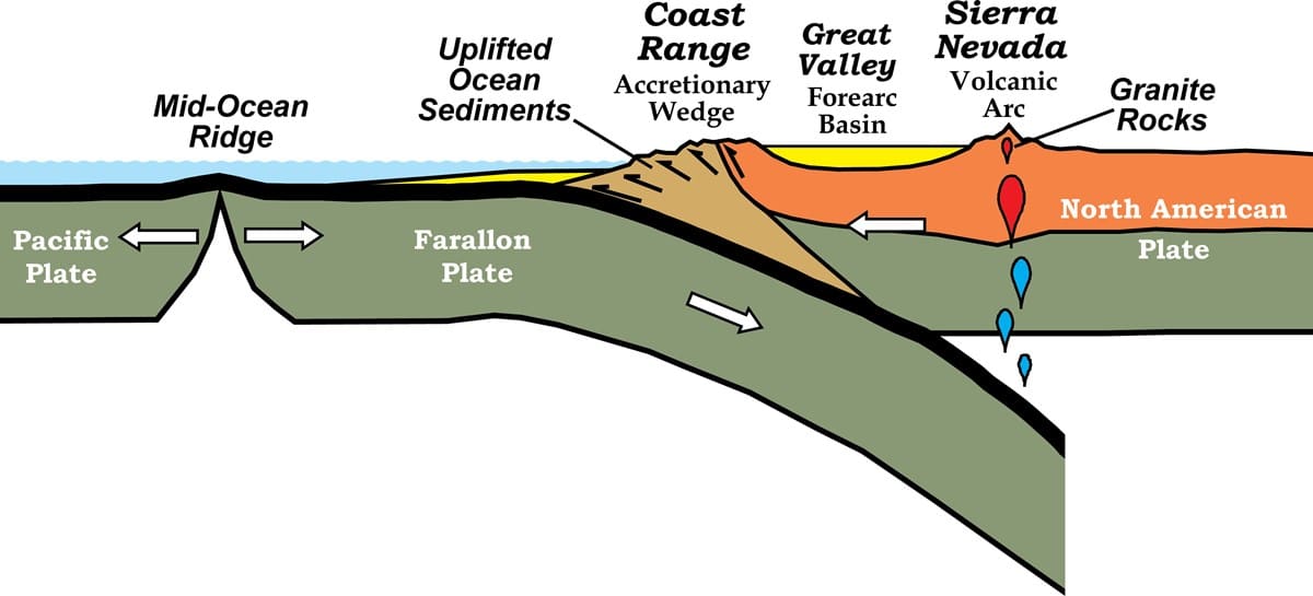
After the Farallon Plate had fully subducted, the Pacific Plate began to subduct too, but the direction of relative plate motion shifted: the Pacific Plate now moves in a north-northwest direction relative to the North American continental plate and subducts off the coast of Alaska. This pull to the northwest initiated the San Andreas Fault, which allows the Pacific Plate to slide past the North American Plate at a transform boundary, without subducting along the California coast.
The northward motion of the Pacific Plate moves more than just the San Andreas Fault, though. The motion gets distributed around the Sierra Nevada and pulls a big chunk of western North America along with it, creating a wide zone of extension called the Basin and Range Province.
The pulling apart of the Basin and Range Province—like opening an accordion—has created a series of mountains and valleys that is the defining feature of this part of the western United States. This extension began approximately 20 million years ago in northern Mexico, traveled northward, and continues today. The Mono Basin began to form about 2.5 million years ago. Seismic activity along the eastern part of the basin during the spring and summer of 2020 is evidence that the region is still tectonically active.
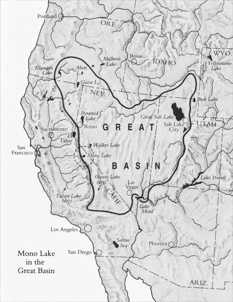
The Great Basin and Mono Lake
The Basin and Range Province largely coincides with the Great Basin, a vast area of the western United States that is internally drained: none of its rivers reach the ocean. Instead, rivers in the Great Basin drain into large, saline lakes like Great Salt Lake, Pyramid Lake, Walker Lake, and Mono Lake.
The Great Basin lakes, including Mono, are much smaller today than they were during wetter periods. “Lake Russell” is the name used for Mono Lake when it was larger and the water was fresher. At several times during the past three million years or so, Lake Russell had an outlet, first to the north into the Walker River system and later to the southeast to Adobe Valley and the Owens River system. As the climate got warmer and drier, the lake level fell and since about 80,000 years ago water no longer reached the outlet, resulting in a closed basin. Evaporation of the lake water left behind a saltier and saltier lake. Remnant shorelines on the hills of Cowtrack Mountain, the Bodie Hills, and the Sierran front near Lee Vining all tell the stories of Mono Lake’s fluctuating water level.
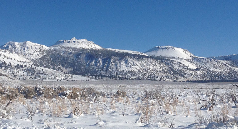
Shaped by fire and ice: Young volcanic activity and glaciation
Some of the most striking features of the Mono Basin are related to relatively recent volcanic activity. Paoha and Negit Islands, Panum Crater, Black Point, and the Mono-Inyo Craters volcanic chain are each the result of eruptions younger than about 40,000 years old. The youngest volcanic features in the Mono Basin are rhyolite flows on Paoha Island, which erupted between 1720 and 1850 C.E.
The Mono-Inyo chain is a north-trending chain of volcanic vents that, with a couple of exceptions, generally get younger from south to north, suggesting a northward propagation of the fissures and the magma system that feeds it. Nearly all of the eruptions from the Mono-Inyo volcanic chain had some explosive activity that ejected pumice and ash. The pumice that blankets the southern part of the Mono Basin, including the June Lake area, originated from the Mono-Inyo chain.
There are two other major volcanic systems in the region—Long Valley Caldera and the Mammoth Mountain volcanic field—but each of these volcanic fields appears to be a separate system, with geochemical characteristics distinct from the others. Long Valley Caldera is unlikely to produce more eruptions; the subsurface heat and hydrothermal system that feeds Hot Creek Geologic Site, for example, is probably the tailing end of the volcano’s activity. Mammoth Mountain is still active, though, as is the Mono-Inyo Craters volcanic chain.
Future volcanic eruptions in the Mono Basin
The Mono Craters will likely produce more eruptions in the future, though they seem to be in a dormant phase currently. The youngest volcanic features in the Mono Basin are Paoha and Negit Islands, where a couple of small rhyolitic lava flows erupted around 1850 C.E. The bathymetry of Mono Lake also shows that there are four or five features near Paoha Island that may be a small cluster of underwater vents.
Any future eruptions would probably occur on the northern side of the lake, but could occur anywhere along the Mono-Inyo Chain. The California Volcano Observatory (CalVO) of the US Geological Survey is tasked with monitoring the potential for eruptions throughout California.
Glacial history of the Mono Basin
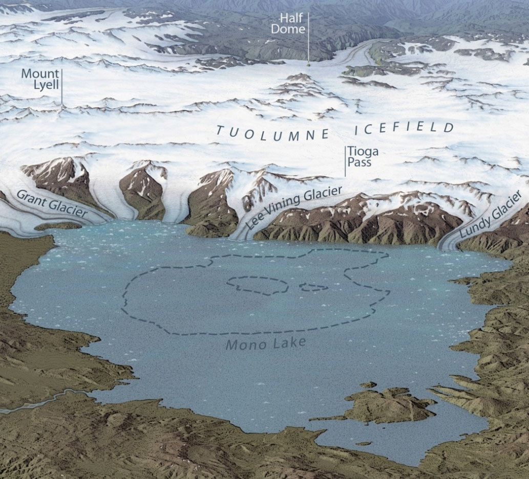
The Sierra Nevada has been glaciated repeatedly over the past three million years or so. Geologists recognize at least 11 episodes of ice advance. The most recent advance, called the Matthes glaciation in the Sierra Nevada, occurred during the Little Ice Age, between about 1350 C.E. and 1850 C.E.
Moraines are giant piles of loose sand, cobbles, and boulders that are deposited beneath and around the edges of glaciers. Geologists map moraines and their complex ridges in order to understand the various glacial periods that formed the landscapes we see in the Sierra Nevada and elsewhere. The largest moraines in the Mono Basin, like those around the Grant Lake Reservoir dam, Bloody Canyon, and Lee Vining Canyon, were mostly formed during the Tahoe glaciation, which peaked about 50,000 years ago, and the Tioga glaciation, which peaked around 20,000 years ago. At those times, ice would have completely filled the canyons and spilled out into the Mono Basin. A much larger Mono Lake would have hosted icebergs calving off these enormous ice fronts.
Other shorter or warmer glacial periods since the Tahoe and Tioga glaciations have left smaller ridges and deposits plastered onto the sides of these large moraines. Usually early evening, just before sunset, is a good time to see these more subtle ridges on the larger moraines because of the shadows that form and reveal them.
Geologic explorations in the Mono Basin
Panum Crater
Walk into the heart of a volcanic vent! Panum is a classic example of the rhyolitic eruptions that characterize the Mono-Inyo Chain. The outer ring of the dome is circumnavigable by way of the rim trail, a longer trail in soft sand. There is also a shorter trail that climbs to the top of the plug dome, which offers spectacular vistas of the Sierra Nevada and the entire Mono Basin. Tours of Panum Crater are offered regularly in the summer.
Reversed Peak
A strenuous but rewarding four-mile (round trip) hike to the top of Reversed Peak offers spectacular views of the whole Mono Basin and a particularly good look at the glacial geology of the June Lake Loop and Grant Lake Reservoir moraines from above.
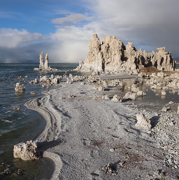
South Tufa
Take a leisurely walk through tufa towers along the shore of Mono Lake. Tufa is calcium carbonate—the same stuff as limestone or travertine—that formed underwater where freshwater springs mix with the alkaline lake water. Learn more about tufa at Mono Lake.
Further Reading
Geology Underfoot in Yosemite National Park, by Allen F. Glazner and Greg M. Stock
Roadside Geology of Northern and Central California, by David D. Alt and Donald Hyndman
Geology of the Sierra Nevada, by Mary Hill
Geologic map of the Long Valley Caldera, Mono-Inyo Craters volcanic chain, and vicinity, eastern California, by Roy Bailey
Quaternary history of the Mono Valley, California, by Israel Russell
Learn More
Top photo courtesy of Dick Erb.