October 2010, the Mono Basin’s warmest October since 2005, set a new record for precipitation in Lee Vining: 3.74 inches! With data going back to 1988, last month beat the old record of 2.41 inches set in 1992 by 1.33 inches! It also beat the 1950-1988 October precipitation record from the Mono Inn, the previous home of our weather instruments (5 miles north). Median October precipitation in Lee Vining is 0.23 inches, usually our third driest month after June and July.
At Cain Ranch, just five miles south but slightly drier, 3.11 inches of rain set a new record going all the way back to 1931! The previous October record was in 2009, with 2.83 inches of precipitation. Click here to see the unofficial October daily log from our live internet weather station (that reads slightly higher rainfall than the official NOAA Cooperative Observer weather station a few feet away).
The storm this October 4-5-6th managed to drop a lot of precipitation east of the Sierra. The Nevada Department of Transportation’s rain gauge 3 miles past the state line near Anchorite Summit recorded approximately 62% of the Lee Vining rainfall during that storm (during a month when it averaged 40%). Rainfall from the storm on October 24th, on the other hand, only got as far east as Highway 395–Anchorite recorded less than 2% of Lee Vining’s precipitation that day. Most of that Sunday it was sunny in town while windblown rain pelted us from the west, resulting in a double rainbow visible over Mono Lake.

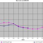
Mono Lake responds to precipitation–an inch of precipitation on the entire lake raises the lake about an inch–and the early October storm caused it to rise 0.07 feet (0.8 inches). By the end of October, Mono Lake had a net rise of 0.045 inches–or zero change when rounding to the nearest tenth of a foot. Mono Lake almost always drops in October due to evaporation (except in 1995 and 2006 when it remained steady and in 1982 and 1983 when it rose) according to monthly lake level records since 1979, so our record rainfall has resulted in an almost once-in-a-decade situation for Mono Lake.
On August 1st, Mono Lake was at the same level as on the same day the previous year, and this happened again sometime during that early October rainstorm. During the next few months it will be interesting to compare the weather, runoff, and lake levels of 2009 and 2010. Because the lake levels are so similar, these two years could be useful in calibrating the lake level models to the weather and runoff conditions. We are currently working to resurrect lake level models from the early 1990s in order to better understand how recent fluctuations compare to modeled results. See the Fall 2010 Mono Lake Newsletter (available to members now and to the public in a month) for more on that effort.
