A superlative drought continues for California and the impacts are unprecedented. Wherever you live in the state you can’t easily ignore the feeling that winter has been mostly absent. Rain and snow have largely missed California four years in a row. Record dry and warm conditions have combined to produce the worst drought in the state’s recorded weather history. By some measures it’s the most acute in 1,200 years.
The central Sierra Nevada sits at the epicenter of the worst drought conditions. Mono Lake and the Eastern Sierra remain at the boundary of exceptional and extreme drought categories as defined by the US Department of Agriculture. It has been so dry that Lee Vining and the Mono Basin have lost roughly the equivalent of an entire year’s worth of precipitation within the last three. So far this water year, we are running at 23% of normal with more than half of the winter past us. Record warm temperatures in the Sierra continue with increased sublimation, evaporation, and further dehydration of soils.
For a terminal lake, the balance sheet of precipitation and temperatures is the bottom of the watershed—Mono Lake itself. The lake is now five feet lower than it was before the drought began. Evaporation has greatly exceeded input. If this year remains dry, Mono Lake will lose another 1.5 feet of elevation, approaching a 20-year low-stand.
Drought in a parallel universe
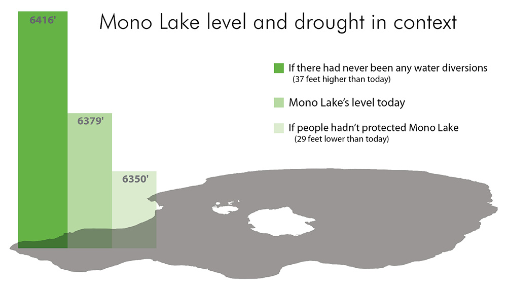
Mono Lake is lower because of drought, but that doesn’t tell the whole story. Since 1941, the Los Angeles Department of Water & Power (DWP) has diverted 4.28 million acre-feet (af) of water from the Mono Basin—water which would have otherwise ended up in the lake.

What if DWP had decided not to extend the Los Angeles Aqueduct to the Mono Basin? What if the lake’s tributary streams had never been diverted at all? The entire basin would look very different. Lower Rush and Lee Vining creeks would have retained robust riparian corridors, complex deltas, and thriving fisheries. Mono Lake would be perched at just over 6416 feet above sea level—37 vertical feet higher than we see it today. The landbridge between Negit Island and the mainland would be completely submerged, protecting the California Gull colony and other nesting birds from coyotes. Expansive alkali flats, the source of violations in air quality regulations, would be covered with many feet of water. The lake would retain an ecologically healthy salinity and waterfowl habitat would remain rich and extensive around stream deltas and the lakeshore.
The “what if” elevation of 6416 feet takes into account the loss of elevation due to the current, historic drought. We might still be concerned about the lake in this alternative scenario, but the drop in lake level would be well within the lake’s natural long-term fluctuation. Our “what-if” lake would be one foot lower today compared to the actual lake when diversions started in 1941.
Return of the landbridge
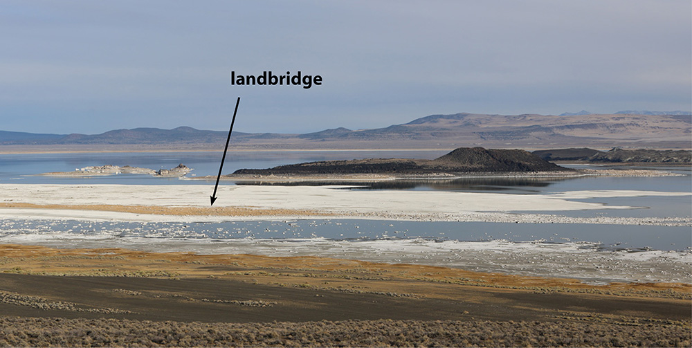
With the record warmth and drought that have pushed Mono Lake five feet lower comes 2,800 acres of newly exposed land. Between Black Point and Negit Island, the lake is particularly shallow and the visual impact is pronounced. The infamous landbridge is making a comeback.
One of the reasons for raising the level of Mono Lake was to keep the landbridge submerged, thereby maintaining a barrier between coyotes and the California Gull colony. Though relatively few California Gulls have returned to nest on Negit Island, nearly all of the gulls continue to nest on the nearby Negit Islets—perilously close to the growing landbridge. Coyote predation was periodically documented on the Negit Islets between 1989 and 1996 when one or more coyotes crossed up to 200 meters of open water. Today the lake level is the same as it was in the spring of 1996, and it’s expected to drop further through the coming spring.

Stepladder recovery
There are three lake level thresholds that determine stream diversions: 6377, 6380, and 6391 feet above sea level. The higher the lake, the more water for Los Angeles. The lake can rise and fall within a year, but April 1 is the day when lake level matters the most—the day that fixes diversions for the year.
You can think of the lake levels as a three-rung stepladder. When we are standing on the ground we are below the lowest rung—6377′. If at any point Mono Lake drops below 6377′, or is projected to, no diversions are allowed. Once we step onto and above the 6377′ rung, diversions to Los Angles can flow at 4,500 acre-feet per year. The next step is 6380′. When we reach this point diversions flow at the rate of 16,000 af per year. The final rung on the ladder requires the biggest step—6391′. This is the final step, and the diversion rules change so we never drop far below it again. Once here, the lake is projected to stabilize at a long-term average of 6392′ and DWP can divert much more water each year, excepting the amount required to maintain the creeks and lake level.
Drought has knocked us off the second rung, so we are below 6380′. On February 1, 2015 we stood at 6379′—between the first and second rung. The April 1 measurement will match this, barring an extremely wet conclusion to the winter. This year DWP will reduce its diversions from 16,000 acre-feet to 4,500 acre-feet.
The temporary loss of diversions from the Mono Basin adds up to roughly 2% of the city’s total water use. When Mono Lake eventually reaches its management lake level of 6392′, Los Angeles stands to gain as much as 6% of water supply relative to current estimated use.
The wisdom of D1631
When the California State Water Resources Control Board issued Decision 1631 in 1994, modifying DWP’s water license, no one knew exactly how long it would take for the lake to reach the 6392′ management level. Predictions and modeling always came with the caveat, “It depends on the climate.”
Over two decades ago when the State Water Board was piecing together their “stepladder” solution for achieving a future, managed lake level, they understood that California’s precipitation was highly variable. They anticipated that Mono Lake would rise and fall with streaks of wet years and drought. The State Water Board was careful to choose a balanced approach to diversions that would provide some protection against drought while also considering the water needs of Los Angeles.
The current drought is the worst the lake has endured since the decision was implemented, and the first time that DWP’s diversions will be reduced based on the decision. DWP is expecting the reduction and is prepared. Meanwhile, Los Angeles is committed to meeting ambitious new water conservation goals while implementing strategies to better cope with climate change and extreme drought.
Accelerated change in Los Angeles
Los Angeles is a veteran of drought, conservation, efficiency, and adaptation. Thoughtful changes began in the late 1980s when a previous stretch of critically dry years threatened water supplies. Today the city uses less water than it did 40 years ago despite a 25% increase in population. Los Angeles has the lowest per capita water use of any major US city with a population greater than one million. The city continues to push hard to conserve and reduce its reliance on imported water.
In October 2014, Mayor Eric Garcetti issued an executive directive to reduce fresh water consumption by 20% and to slash the city’s reliance on imported water by 50%. The detailed directive provides a long list of actions with target thresholds affecting residential customers and all levels of city government. The order also creates a new Mayoral Water Cabinet to oversee progress on water policy goals while moving forward on three key areas; (1) developing a strategy to increase local water supply through stormwater capture, recycled water, conservation, and groundwater remediation, (2) recommending a new tiered water rate system that better encourages conservation, and (3) initiating a statewide leadership position on water reuse and stormwater capture.
Drought and climate change are forcing change, and Los Angeles is moving decisively. If you’re a DWP customer, you might not see the difference in your water bill just yet, but if you have a lawn, the price to replace it with a drought-tolerant landscape just went up to $3.75 per square foot.
Looking ahead
We have already entered conditions predicted by climate modeling. Extreme drought year types are expected to increase in frequency, along with more extreme rain and floods connected to atmospheric river events. Decreasing Sierra snowpack and earlier spring runoff is already occurring. Warmer overall temperatures have been trending in California for decades. Last year was the warmest in the history of the state, by a record margin.
Since the 21st Century began, 11 of the last 16 years in California have ranked the warmest on record. Every year since 1998 has produced average temperatures above the 1901–2000 mean. It is getting warmer, and the droughts of the past aren’t comparable with those of this century now that increasing temperatures are at play.
The consequences of climate change are large, complex, and affect us all. The Mono Lake Committee is asking questions and seeking answers in terms of what this change means for the Mono Basin. As a group of concerned citizens who care about the lake and streams, it is part of our mission to figure out what lies ahead for Mono Lake. At the same time, neither the state nor the federal government have the time nor the resources to dedicate to climate change issues on the ground. While Los Angeles is working quickly to improve water and energy efficiencies, we know that DWP’s efforts will not be focused on the condition of Mono Lake except as required by the State Water Board. Finding solutions that work for Mono Lake will be up to the Mono Lake Committee and all of us as we navigate future conditions.
This post was also published as an article in the Winter & Spring 2015 Mono Lake Newsletter.

Excellent review and brief summary of Mono Lake water diversion. Thanks so much.