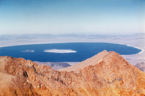
This just in from my inbox this morning … what a treat! This shot was taken from Mount Dana in 1953, which means the lake level was around 6408 feet above sea level. For perspective, the pre-diversion lake level was 6417 feet, and Greg was just out measuring the current level of 6382.14 feet. I was amazed to see the islands and the area around the landbridge covered in water as well as the shape of the south shoreline. 6392 here we come!
I’m always excited to see historical photos of Mono Lake, and they’re really useful tools for the Committee too, so if you or anyone you know has any historical photos from the Mono Basin please contact me! Thanks to our friend Dane Henas who helps with the Mono Lake Calendar for passing this along from his neighbor Wallace Fung!
- Mono Lake circa 1953. Photo courtesy of Wallace Fung.


Amazing photo.
Dana is definitely on my to-do list next summer!
Be sure to take a photo from the top!