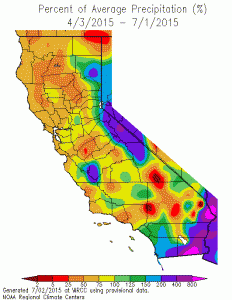
At the Cain Ranch weather station, five miles south of Lee Vining, as of July 13, 1.57 inches of rain had fallen in July. That makes this month already the second-wettest July on record after the 1.98 inches of rain in July 1965. Records at this location began in 1931. Rain fell on all but two days between July 1 and 10, and while it has been dry there since July 10, it still has been raining in other parts of the Mono Basin almost every day.

Lee Vining Creek above the Los Angeles Department of Water & Power (DWP) diversion dam experienced its peak flow of about 124 cubic feet per second on July 11, from rain and melting fresh snow. Below the dam, the minimum flow is being released, and the floodwaters are being diverted to Grant Lake Reservoir, which has been slowly rising since May.
Aside from brief floods due to thunderstorms, the Mono Basin’s creeks are dropping to the very low levels that were otherwise expected this summer. If the thunderstorms stop, we will start seeing new low flow records later this month, especially in watersheds without glaciers, such as Walker Creek. The April–September snowmelt runoff forecast issued by DWP in May predicted 19% of average runoff, with a lower bound of 7% and an upper bound of 32%. Nineteen percent is less than half of the runoff measured in 1977, the driest year on record; 32% is still much drier than the driest year on record. Thanks to the recent wet weather, Mono Basin runoff is on track to reach 32%.
