
The Draft Subsequent Environmental Impact Report (DSEIR) for the Tioga Inn project identified five significant and unavoidable adverse impacts. Despite a large and comprehensive public response voicing concerns over these impacts, the Final Subsequent Environmental Impact Report (FSEIR) declared:
“The significant and unavoidable adverse impacts that were identified in the DSEIR will remain significant and unavoidable if the proposed Tioga [Inn] project is approved, even with modifications proposed in this FSEIR.”
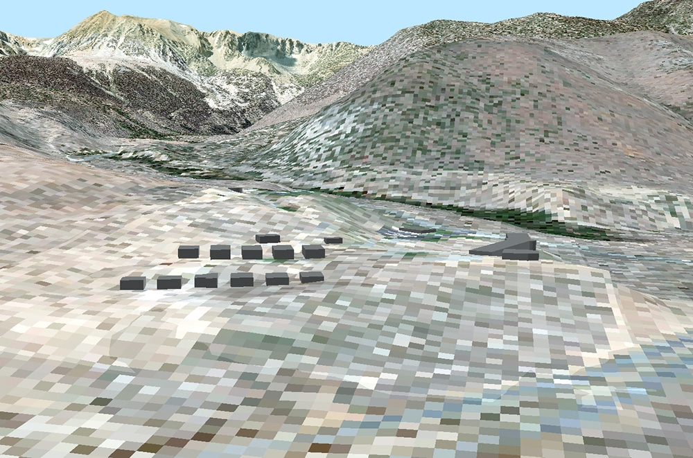
Of these five impacts, impacts to scenic views were the hardest for me personally to fully comprehend since no 3-D models were provided to demonstrate what the project would look like after grading and construction were completed. Notably, the FSEIR acknowledged that project impacts to aesthetic resources were the most common and frequent concern from comment letters. To better understand what the final project as proposed in the FSEIR would look like I conducted a 3-D visualization and viewshed analysis using ArcGIS.
Where in the Mono Basin can you see the project?
The location of the proposed housing is a very prominent location at the foothills of the Eastern Sierra, so finding out that you could see these structures from many vantage points throughout the Mono Basin should not be very surprising, but honestly it was for me. My viewshed analysis (Figure 1) demonstrates that both the one- and two-story buildings will be visible from the entire trail network and water’s edge at South Tufa as well as Navy Beach. However, there are statements from the FSEIR that ambiguously refute the Navy Beach visibility results from my analysis. Two statements summarize this ambiguous point (p66 of the FSEIR):
“The lowered profile, in combination with the redesign of the most prominent structures as 1-story building rather than 2-story structures, also minimizes the line of sight (and thus site visibility) from Navy Beach.”
“Views of the lower six 1-story units would also be entirely screened from view at Navy Beach.”
Whether the line of sight to Navy Beach is minimized or entirely screened is unclear to me from these two statements and there are no qualifications or additional data provided by the FSEIR to help the reader determine the validity of either of these statements. On an intuitive level however, I’m unclear how visibility of the buildings would exist at South Tufa and not at Navy Beach when you consider that Navy Beach is located at a further vantage point with no significant topographic barriers in between.

What would the project look like?
The size of this project is larger than anything Lee Vining has ever seen before. Even with mitigations, including the “Shaker gray” building color and the utilization of some one-story buildings (instead of two-story) on a graded platform, the FSEIR determines that the project will have a significant adverse impact on aesthetic resources and glare. During the comment period for the DSEIR, there were many suggestions for how mitigations could feasibly reduce impacts to less than significant, but this goal was not accomplished in the final Project plan and the FSEIR.
What will you see?
Light will catch the structures at different angles throughout the day, producing varying reflection patterns from the sun that could be visible anywhere in the Mono Basin that I’ve identified as “visible” in the Tioga Inn viewshed map (Figure 1). For example, Figure 3 below demonstrates how a 2×3-foot piece of glass positioned adjacent to the project site can very clearly reflect sunlight to South Tufa. This type of visual impact would happen frequently and damage the unique scenery at Mono Lake.

What does this all mean?
To understand how this project impacts scenic resources, you need look no further than the FSEIR. The bottom line is clear: the project as proposed will have a “significant and unavoidable direct and cumulative impact” to “Scenic Resources and Visual Character” (p41 of the FSEIR/Updated DSEIR, June 2020). Additional mitigations proposed during the comment period for the DSEIR by the community that could have mitigated these impacts to less than significant were ignored or not used fully by the project proponent.
What this means for me is I will likely see this structure at different times throughout the day. And for the visitor who comes to Mono Lake for the very first time, allured by the scenic beauty they’ve seen in photos, it means that when they go to South Tufa to capture their own photo of the tufa towers, they will see a degraded view instead of the one enjoyed by millions of visitors before them.
Top photo by Bartshe Miller.