
Yesterday I was refreshing the California Cooperative Snow Surveys Webpage almost every hour. Over and over again I saw the dramatic pattern across the state—higher double-digit percentages at the highest elevations of almost every watershed, and lower or zero snowpack at the lower elevations.
Finally, this morning, the rest of the Mono Basin data appeared! The good news is that the snowpack in most of the Mono Basin isn’t as bad as the 6% of average at Tioga Pass and Saddlebag Lake. The bad news is that with only 14% of average snow water content, the snowmelt runoff will be lower than anyone anticipated.
Gem Pass, at the highest elevation, tops the charts with 25% of average snow water content. Everywhere else, snow surveyors measured the lowest snow water content ever measured on April 1st. Ellery Lake is 21% of average, and Gem Lake is 12% of average. Also in the Mono Basin, but reported under the San Joaquin River drainage, is Agnew Pass, which lost 7.5 inches of water in March, and currently is only 3% of average (1 inch of water content).

The following is a summary of the five Mono Basin snow courses:
- Gem Pass lost 2 inches of water in March, and at 8.5″ is about the same as 1977, although not as dry as 1931.
- Gem Lake lost 5.5 inches of water in March, and at 3.5″ is driest on record (beating 5.9″ in 1976).
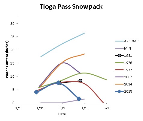
- Tioga Pass lost 6 inches of water in March, and at 1.5″ is driest on record (beating 7.4″ in 1977).
- Saddlebag Lake lost 6 inches of water in March, and at 2″ is driest on record (beating 9.9″ in 1977).
- Ellery Lake lost 1.5 inches of water in March, and at 6″ is driest on record (beating 9.7″ in 1977).