We were expecting the worst for streamflows this summer. Runoff at 48% of average this year—as forecasted in April, and even lower than the last two dry years—would make 2014 the driest year of the last three, adding up to the three driest consecutive years on record for runoff in the Mono Basin.
But then the summer thunderstorms came, dropping an inch and a half of rain. The late July and early August rains extended the late July streamflows into mid-August, buying about 3–4 weeks of extra time at or above the late July flows. For most creeks, this means that the late July and early August flows this year ended up actually higher than last year. Click on the graphs below to enlarge.
Walker Creek
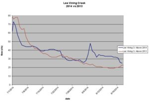
The most dramatic impact has been on Walker Creek. Last year it got down to 1 cfs on August 8, and remained near 1–2 cfs the rest of the year. With even drier conditions forecasted this year, I expected it could dry up before reaching Highway 395. But this year, thanks to the rain, as of August 21, it has remained at or above 3 cfs.
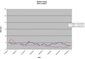
Lee Vining Creek
Lee Vining Creek declined to 26 cfs before the rain, at about the same rate as last year, and now following the rain is back down to that flow rate. That is about two weeks at or above that flow than would have occurred without the rain.
Parker Creek
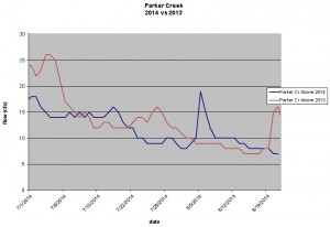
Parker Creek declined to 7 cfs about a week later than last year, although late August thunderstorms gave it a bump in flow in 2013. Overall the summer 2013 and 2014 flows, outside of the rain events, were similar.
Rush Creek
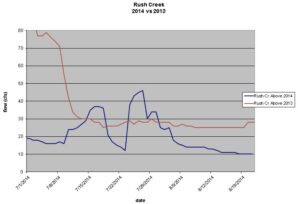
Rush Creek between Silver Lake and Grant Lake Reservoir reached 12 cfs before the rain, and just declined to that flow again last week, buying it an extra three weeks at that level. But this is a very low summer flow, notwithstanding an unusual 7 cfs minimum in July 2012. It is less than half the flow at the same times last year, and currently it is running at only 10 cfs, or only 1/3 of the flow last year on this date. The last time Rush Creek reached 10 cfs in August was in 2007. Rush Creek reached 11 cfs in August 2001, but otherwise has not been this low in August in at least three decades. Rush Creek’s flow below Grant Lake Dam is much higher (at least 31 cfs) due to the State Water Board’s minimum required flows in Decision 1631.
These flows are all measured above the Los Angeles Aqueduct, and Rush Creek and Lee Vining Creek are controlled by upstream reservoirs. However, the reservoir levels tend to stay steady in summer, meaning that these flows are likely fairly close to the unimpaired flow that would occur if there were no dams.
The thunderstorms gave the creeks a midsummer reprieve from even drier conditions during this extremely dry year, but there is no rain in the forecast for the rest of August. And late summer and fall are often the driest times of year in the Mono Basin.
As for Mono Lake, it got a reprieve due to the thunderstorms too. Last year it dropped 0.7 feet in July and August. This year, with a week and a half to go in August, it has only dropped 0.33 feet, to 6379.78 feet above sea level as of August 20. Things are bad during this drought—but without the 2014 summer thunderstorms, they would be worse.

[…] Summer thunderstorms give Mono Lake and its tributaries a drink and a break: “We were expecting the worst for streamflows this summer. Runoff at 48% of average this year—as forecasted in April, and even lower than the last two dry years—would make 2014 the driest year of the last three, adding up to the three driest consecutive years on record for runoff in the Mono Basin. … ” Read more from the Mono-Logue here: Summer thunderstorms give Mono Lake and its tributaries a drink and a break […]
“Thank God for little favors.”
Thanks, Greg, for the informative updates. Having just taken the committee’s Los Angeles Aqueduct field seminar in July, your commentary means that much more to me. Even knowing the basics of what we covered in the seminar, such as exactly which streams are subject to diversions, and having see the actual diversion hardware, well, it all means a lot more now. I look forward to future updates from you regarding the hydrology of the Mono basin. Thanks again.
From these Carolina Pines – which are verdant and quite moist, i send my deep regrets to all the farmers, vineyard and orchard owners. Wish we could truck in enough water to bring you all back to a normal range! My heart is in the Owens Valley – which I have always considered my home.
Jo Sanders
Hello Mono Lake Protecters,
How is it that the LADWP is drawing Owens Valley water into the L.A. basin at this time? I have seen, of late, heavy amounts of water coming down the infamous water ladder feeding the Vanowen Resevoir. I live near this location and cringe every time I see water coming down this thing. Thanks for your response!
Ron Hopkins
Committee member
Hi Ron,
By our preliminary calculations, last year about 50% of the water in the LA Aqueduct came from the Mono Basin. It is usually 4-12%, but in dry years the flow from the Owens Basin is so low that the Mono Basin water is a bigger percentage. In fact, in 2013, more water was used in the City from local groundwater sources than from the LA Aqueduct! So there is a lot less water than usual coming from the Eastern Sierra during this drought.
Based on the data here http://wsoweb.ladwp.com/Aqueduct/realtime/sdrealtime.htm it appears that on August 26th the entire flow was shifted from the second aqueduct to the first. That shift (possibly due to maintenance work) is probably responsible for the sudden changes you are seeing. The total flow didn’t change very much, and it is only put down the Owensmouth Cascades when it needs aeration.
Thank God for a little rain. Let’s hope we have snowy winter.
That is disgusting that the DWP draws so much from the Mono Basin in dry years. Is there any way than we can get a court order for DWP to draw less water from the eastern sierra’s during recognized, by the governor no less, drought years. These droughts are cyclic and they can last a long time. Also, with climate change the unpredictability of weather becomes even more so.
Hi Donna,
The State Water Board, in its 1994 Decision 1631 protecting Mono Lake, tied water exports to lake level. DWP is limited to 16,000 acre-feet of surface water diversions when Mono Lake is higher than 6380 feet above sea level on April 1st. Next year, it probably will be below that threshold, and exports in that case would be limited to 4,500 acre-feet. If it drops (or is projected to drop) below 6377, surface water exports must stop. This limitation protects Mono Lake as it drops, but it also makes Mono Lake act kind of like a reservoir for the city that ensures a reliable high quality water supply when it is higher than 6380. That is a good thing for both LA and Mono Lake–everyone has the same goal to keep Mono Lake as high as possible–and the reason why D1631 was such a victory. Don’t worry–if this drought lasts longer, exports will be reduced and then stop. Since we can’t control the climate (at least not very easily in the direction we’d like it to go), unfortunately we have to wait for wet years, and these low Mono Lake levels are very depressing!
Thanks Greg for the info. Yes, very depressing; I haven’t been to the Lake much this year but when I was there the bird life was down from the summer before and the osprey nest numbers seemed less. Was I imagining this or has there been a noticeable decrease in birds, such as gulls and phalaropes and osprey. Here in Mammoth Lakes area I haven’t seen one Orange-crowned Warbler and the alders along a certain section of Mammoth Creek have died along with the willows. I have definitely noticed a decline in birds around my home. Very, very depressing. Some good news, however, the Long-eared Owl nest I monitor fledged 3 chicks although the surrounding meadow where she nests was dry dust and I have partially located a Northern Goshawk nest which fledged at least 2 chicks. Sorry for reporting this here but just very excited about the raptor community in Mono Co.