
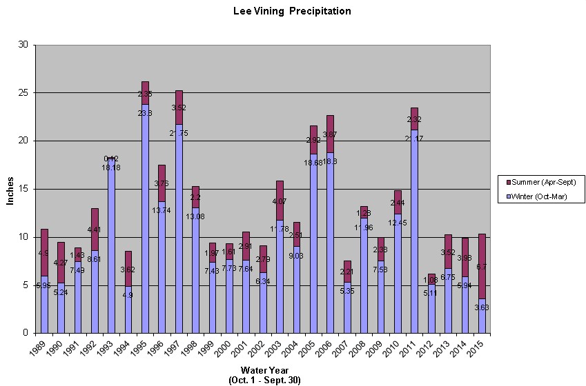
The Mono Basin is a land of extremes, and this year’s weather is no exception. Temperatures since January are the warmest on record. October–March precipitation in Lee Vining was the lowest on record. April–September precipitation, on the other hand, already is the highest on record—and we are only halfway through that time period! This water year (October 1, 2014–September 30, 2015) is the first time Apr–Sept precipitation has exceeded Oct–Mar. This reversal of the warm and cold season Mediterranean precipitation patterns has allowed invasive plants like cheatgrass to spread impressively this spring.
At Cain Ranch, five miles south of Lee Vining and farther from the Sierra front, where it is influenced less by winter precipitation, Apr–Sept precipitation has exceeded that of Oct–Mar only four times: 1976, 1977, 1989, and 2015. This year, 4.03″ of May–June precipitation beat the old record of 3.57″ set in 1977. 1977 was the driest year on record.
There was so little snow remaining in April, that the runoff forecast for this summer was just half of what was measured in 1977. The spring snows and summer rains are increasing the runoff above what was expected, and that, plus direct precipitation on the lake, has helped to keep Mono Lake’s level steady—it has fluctuated less than 0.3 feet since October, and is now the same level it was in April and half a foot higher than DWP’s forecast. This is very good news, but even if runoff is almost double expectations, 2015 would still remain the driest year on record for runoff. That is how amazingly dry it has been.
Localized thunderstorms on most days this week kept the rains coming. On June 30th, but recorded on July 1st, 1.18 inches of rain fell in about 20 minutes in Lee Vining, making this the fifth-wettest July on record—before July officially began. Every little bit helps to ameliorate the impacts of record drought.
With the shifting pattern to more winter rainfall instead of snow and lots of thunderstorms recently, we installed rain barrels (served by rain gutters, which are a challenge to protect in snow country, but useful when it rains), AND…YESTERDAY IN ONE SHORT COLOUDBURST WE FILLED TWO BARRELS WITH TOTAL OF 60 GALLONS of water coming off just part of our roof in Mono City. Have about 90 gallons stored ,now, after this week of showers, to use when it gets dry again for watering plants outside. Amazing how much water can be gathered off a roof!
If the rain fell in June why did you not measure at midnite and record it as June? This recording temps and precip in the morning but occurred yesterday except for the minimum temperature does not make sense. I believe you will find ‘in the old days’ it would be recorded as June 30.
Bob, we are not here at midnight, we measure once a day in the morning. Precipitation has always been recorded for the 24 hours prior to the observation, as is directed on the form used by Cooperative Observers, NWS form E-15, “Record of River and Climatological Observations”. On the other hand, you are correct that a few years ago our methodology for recording the timing of the max and min temperature changed. The form directs that temperatures also should be recorded over the past 24 hours, but now we record the minimum temperature after midnight and not over the last 24 hours. I would have to investigate to remind myself of the reason, but I think this happened when a new MMTS was installed that required a specific time for a reset (instead of the old one that measured since the last reset), and since our observation time varies by an hour depending on the time of year, using the old methodology would have resulted in inconsistent timing or missing more readings. So our minimum temperature now is after the midnight reset, which is usually the case anyway when examining the previous 24 hours. I would make a friendly amendment that letting the technology drive the methodology does not make sense, but given this limitation, there appear to be good reasons for these methods.
Greg; thanks for the reply. The MMTS can be pulled up for past data for at least of month. One could just go and pull up June 30th. Of course who am I to ask the NWS to change back to the old days. where readings were made at about 5pm. What I do not like about the morning readings is recording the precip and max temp as if it was recorded today, not yesterday. I know the summer ranger at Tuolumne Meadows records the data like max temp as yesterday’s reading and of course the minimum is for today. Again, Greg, thanks for the info. I just do not like MMTS instruments as sometimes the power goes off which happens at Mammoth Ranger Station, The line is cut which also happened at Mammoth, the calibration gets out of wack which happened at SNARL as well as several other stations I follow. Notified the observers and they had it re calibrated.